

Flood Control and Disaster Management EVS Notes: CTET and TET Concepts with a Worked Example
Learn how floods turn into disasters, match controls to causes, sort actions across four management phases, and check a fictional evacuation plan step by step.
KnowledgeGate Team
Exam prep & CS education
Updated 13 Nov 20266 min read
A flood is a natural hazard, but it becomes a disaster only when exposed and vulnerable people or assets cannot cope with its effects. That distinction is easy to miss in CTET and TET preparation. Flood causes, control measures, and the disaster-management cycle connect in one numerical evacuation drill.
Flood, hazard and disaster: build the concept map first
A flood occurs when water overflows or accumulates on land that is normally dry. Four types are useful for exam questions:
Riverine flood: a river exceeds its channel capacity.
Flash flood: water rises rapidly, often after intense rain in a steep catchment.
Urban flood: rainfall overwhelms drainage while sealed surfaces restrict infiltration.
Coastal flood: storm surge or unusually high water inundates the coast.
Use hazard + exposure + vulnerability - coping capacity -> disaster risk as a memory aid, not an official mathematical formula. The same high river level may remain a hazard on an empty floodplain. It can become a disaster where homes, a school, livestock, and a blocked evacuation route are exposed.
Flood control and disaster management are related but not identical. Flood control aims to reduce the probability, peak, spread, or depth of flooding. Disaster management also covers warning, evacuation, relief, rehabilitation, and safer rebuilding because no control measure can prevent every flood.
Why floods happen: connect each cause to the process
Natural drivers work through different mechanisms. Intense or prolonged rain supplies water faster than soil and channels can carry it. Saturated soil reduces infiltration, while rapid snowmelt raises river discharge. Cyclones may combine heavy rain with storm surge. A failed dam or embankment, or the sudden breach of a landslide dam, can release water rapidly.
Human activity can amplify these processes without causing every flood. Deforestation and soil compaction increase runoff. Wetland loss affects runoff and environmental balance by removing temporary water storage. Floodplain encroachment increases exposure, concrete surfaces speed urban runoff, and solid waste reduces the carrying capacity of drains.
Driver | What changes | Likely flood type | One suitable control |
|---|---|---|---|
Blocked urban drain | Lower drainage capacity | Urban flood | Drain clearing and waste control |
Saturated catchment plus prolonged rain | High river discharge | Riverine flood | Forecast, reservoir operation where applicable, and floodplain zoning |
Cloudburst over a steep catchment | Rapid runoff | Flash flood | Early warning and no-build zones along flow paths |
Flood-control measures: structural and non-structural layers
Structural measures alter or resist water flow. Reservoirs and detention basins store flow temporarily. Embankments or levees confine water, diversion channels redirect part of it, and storm-water drains move urban runoff. Raised plinths and flood shelters reduce exposure. However, structures can fail or shift risk downstream, so an embankment is not a universal answer.
Non-structural and nature-based measures reduce exposure or vulnerability. They include floodplain zoning, hazard maps, rain and river-gauge monitoring, timely warnings, evacuation drills, permeable surfaces, watershed treatment, afforestation, and wetland restoration. They usually work alongside engineering rather than replacing it.
For a scenario question, first identify the flood type, then locate the failed process and choose a matching layer. A blocked drain needs maintenance and waste control. A settlement in a river floodplain needs zoning, warning, and evacuation planning. A steep flash-flood channel needs rapid warning and strict avoidance of the flow path.
The disaster-management cycle: before, during and after a flood
The four phases form a connected cycle:
Prevention and mitigation reduce future risk.
Preparedness builds maps, warnings, supplies, assigned roles, and drills.
Response protects life through alerts, evacuation, rescue, shelter, safe water, and first aid.
Recovery restores services, livelihoods, homes, and ecosystems while rebuilding more safely.
Classify actions by their immediate purpose. Desilting a blocked drain before the monsoon is mitigation. Checking a shelter register and running a drill are preparedness. Moving residents after a danger warning is response. Disinfecting wells and rebuilding a washed-out road at a safer elevation are recovery, although early recovery can overlap with response.
At home or school, follow authorised warnings and move to designated higher ground. Switch off electricity only when it is safe. Never walk or drive through moving floodwater. Keep children together with accountable adults, and use boiled water or water officially declared safe after flooding. Safety does not require untrained rescue attempts.
Worked example: evacuate a 600-person riverbank village within four hours
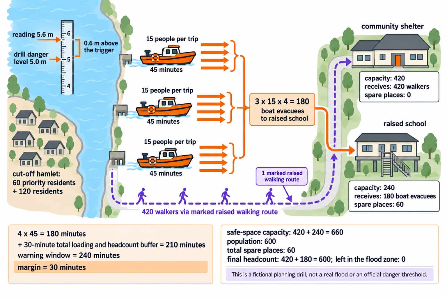
This is a fictional planning drill, not a real flood or an official danger threshold. The gauge reads 5.6 m and the drill danger level is 5.0 m:
5.6 - 5.0 = 0.6 m above the trigger
The warning window is 4 hours, or 4 x 60 = 240 minutes. The population is 600, including 60 residents who need priority help because of mobility or medical needs.
First check safe space:
Community shelter capacity: 420.
Raised school capacity: 240.
Total capacity:
420 + 240 = 660.Spare places:
660 - 600 = 60.
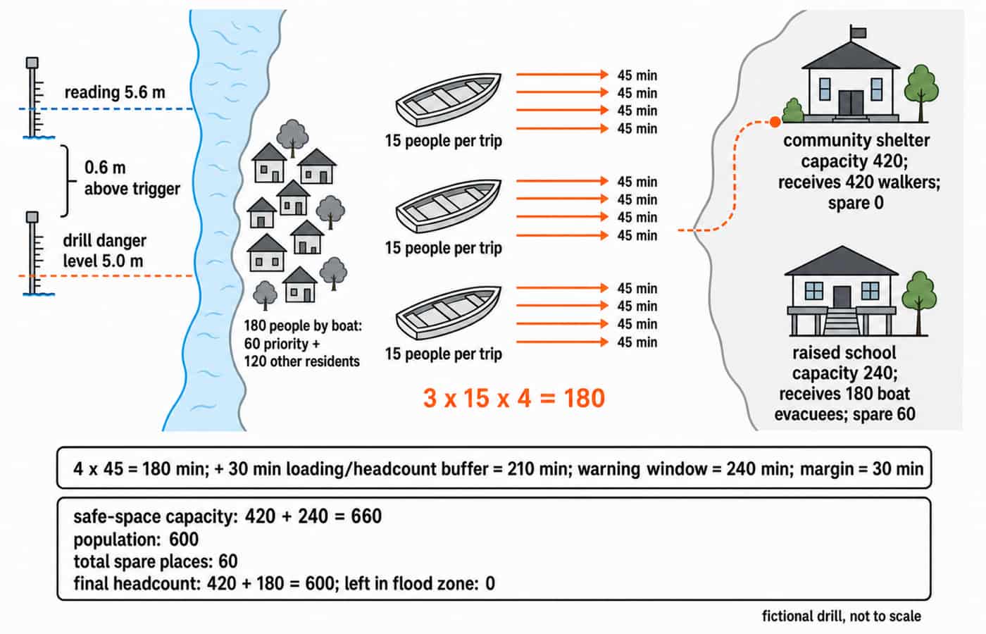
Now check transport and allocation. Three boats carry 15 people per trip and complete four trips each, so total boat capacity is 3 x 15 x 4 = 180. Allocate it to the 60 priority residents and 120 residents in a cut-off hamlet: 60 + 120 = 180. The remaining 600 - 180 = 420 residents use the marked raised walking route to the community shelter.
All 180 boat evacuees go to the school, leaving 240 - 180 = 60 spare places there. The community shelter receives 420 walkers and is full. The final check is 420 + 180 = 600, so 0 people are intentionally left in the flood zone.
The boats operate in parallel. Four round trips take 4 x 45 = 180 minutes. Adding a 30-minute total loading and headcount buffer gives 180 + 30 = 210 minutes. The margin is 240 - 210 = 30 minutes.
Arithmetic supports the plan, but it cannot certify safety. A real evacuation also depends on authority directions, route conditions, weather, boat condition, trained crews, and updated headcounts.
How teaching exams test flood control, plus the traps to avoid
Questions can ask you to match a flood type to its cause, classify an action by management phase, choose the best control for a short scenario, or design a child-centred EVS activity such as mapping local drains or sequencing a safe school drill. The move from subject knowledge to classroom treatment is developed further in CTET EVS pedagogy.
Trap | Correct idea |
|---|---|
A hazard is automatically a disaster | It becomes a disaster when exposure, vulnerability, and inadequate coping capacity produce serious disruption |
Response is the whole cycle | Response is one of four connected phases |
Dams and embankments are the only controls | Zoning, warnings, drainage, wetlands, and preparedness also reduce risk |
Afforestation prevents every flood | It can reduce runoff, but it cannot guarantee that flooding will not occur |
Immediate rescue is mitigation | Rescue is response |
Shallow-looking floodwater is safe | It may be moving, contaminated, or electrically unsafe |
For exam-specific scope, check the current syllabus or bulletin issued by the relevant exam authority. Any claim about paper structure, marks, dates, counts, or exact syllabus wording must come from that official source.
Short version and the next study step
Use this five-step revision ladder:
Identify the flood type.
Trace the natural and human-amplified causes.
Combine structural, non-structural, and nature-based controls.
Place actions in the four disaster-management phases.
Test whether the plan protects vulnerable people within its capacity and time limits.
For a 10-minute active-recall drill, reproduce the four-phase cycle and classify the four actions from the cycle section. Then recalculate the village plan from 600 people, shelter capacities of 420 and 240, 3 boats, 15 people per trip, 4 trips, 45 minutes per round trip, and a 240-minute warning window without looking back.
Candidates targeting primary-level teaching can continue with the CTET Paper 1 course or the UPTET Paper 1 course. Both are relevant catalog paths for EVS preparation.
Go deeper with the full courseCTET Paper 1 2026 — प्राथमिक शिक्षक (कक्षा 1–5)
Keep learning

CTET vs State TET: Acceptance, Validity and Which One to Take
Choose CTET, a State TET, or both by checking where each certificate is accepted. Use worked examples to turn your target vacancies into a practical study route.
Updated 9 Nov 20265 min readCTET & UPTET

सामान्य अशुद्धियाँ (Samanya Ashuddhiyaan): Complete Hindi Grammar Notes for CTET and TET Exams
Learn to identify and correct Hindi word-form, agreement, pronoun and redundancy errors through exact examples, a worked MCQ and a scored diagnostic.
Updated 6 Oct 20266 min readCTET & UPTET

Child Development for Teaching Exams: CTET and TET Pedagogy Notes with Examples
Build a usable concept map of child development, then apply it to classroom evidence through examples, assessment choices and a worked fraction case.
Updated 30 Oct 20266 min read98 viewsCTET & UPTET
Natural Resources, Energy and Disaster Management for Teaching Exams: Complete Notes with Worked Examples
Connect resource renewability, primary and secondary energy, and disaster risk through clear definitions, exam traps and a fully worked district case.
Updated 27 Aug 20266 min readUGC NET Computer Science