A contour line joins locations having the same height above the mean sea…
2017
A contour line joins locations having the same height above the mean sea level. The following is a contour plot of a geographical region. Contour lines are shown at 25 \(m\) intervals in this plot. If in a flood, the water level rises to 525 \(m\), which of the villages \(P, Q, R, S, T\) get submerged?
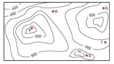
Answer: C. \(R, S, T\) — Given data -> height of all villages P = 575 Q = 525 R = 475 S = 425 T = 500 Villages below the flood level - 525m are R <500m 425m<= S<=450m 500m <=T<= 525m…
- A.
\(P, Q\) - B.
\(P, Q, T\) - C.
\(R, S, T\) - D.
\(Q, R, S\)
Attempted by 68 students.
Show answer & explanation
Correct answer: C
Given data -> height of all villages
P = 575
Q = 525
R = 475
S = 425
T = 500
Villages below the flood level - 525m are
R <500m
425m<= S<=450m
500m <=T<= 525m
Therefore R,S,T is correct.
A video solution is available for this question — log in and enroll to watch it.
Explore the full course: Iocl Engineers Officer Grade A Paper 1