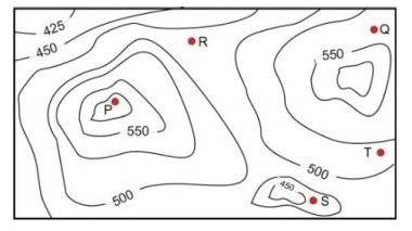
A contour line joins locations having the same height above the mean sea…
GATE · 2017 · CS · Set 1 · General Aptitude
A contour line joins locations having the same height above the mean sea level. The following is a contour plot of a geographical region. Contour lines are shown at 25 intervals in this plot. If in a flood, the water level rises to 525 , which of the villages get submerged?
- A.
- B.
- C.
- D.
Attempted by 164 students.
Sign up free to check your answer
Sign up freeLoading lesson…